
 Afət Ziyadqızı

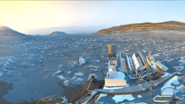
NASA’s Curiosity rover has sent back a rare image captured during a geological survey on the surface of Mars. The photograph, taken with the rover’s Mastcam camera, shows a distinctive rocky landscape shaped by wind erosion. Curiosity has been carrying out its scientific mission in Gale Crater, near the Martian equator, since 2012.
Operative Information Center-OMM reports that Ashwin Vasavada, a planetary scientist at NASA’s Jet Propulsion Laboratory and a lead specialist on the Curiosity project, said the steep peaks in the image differ significantly from geological layers studied so far.
Scientists believe that deposits accumulated by volcanic activity about 3 billion years ago were gradually shaped by wind into distinctive ridges known as yardangs.
Curiosity has climbed to an elevation of about one kilometre above the surrounding Martian terrain along the northwestern section of Mount Sharp. The mountain’s layers serve as a valuable geological record of the planet’s transition from a warm, wet climate to a cold, arid environment.
Vasavada said the rover, which uses “superintelligence” and autonomous navigation technologies, is expected to reach this terrain fully in 2027 or 2028 and analyse rock samples there. NASA currently has two rovers operating on Mars: Curiosity and Perseverance, which is working in Jezero Crater.
Vasavada said the images, taken about an hour after sunrise, bring to mind Arizona’s desert on Earth. He noted that the orange sky and blue hues of dawn create a striking scene characteristic of the Red Planet.